Brevard County
BC36
BC37
BC38
BC39
Indian River-Malabar to Vero Beach
BC40
Aquatic Preserve
BC44b
BC45
BC44a
BC45
BC46
BC47
BC48
Indian River-Malabar to Vero Beach
BC49
Aquatic Preserve
BC50
BC51
BC52
BC53
Legend
Recreation Islands
Conservation Islands
Boat Ramps
Marinas
IRL Aquatic Preserve
Critical Wildlife Area
County Boundary
Esri, HERE, Garmin, (c) OpenStreetMap contributors, and the GIS user community, Sources: Esri, HERE, Garmin, Intermap, increment P Corp., GEBCO, USGS, FAO,
NPS, NRCAN, GeoBase, IGN, Kadaster NL, Ordnance Survey, Esri Japan, METI, Esri China (Hong Kong), (c) OpenStreetMap contributors, and the GIS User
Community
56: SPACE COAST LIVING | SPACECOASTLIVING.COM
>>
Bacon said. “It is very important to have areas for
recreation allowing both humans and animals to
co-exist. As a CSO, we are able to assist with many
projects that ultimately allow better stewardship for
these aquatic preserves.”
Though many spoil islands might be identified by
residents with names ranging from Dolphin Island
to Horseshoe Crab Island, they are listed on IRLAPs
maps according to alphabetical and numerical or
longitudinal descriptions. For example, BC denotes
Brevard County; PB, Palm Beach County; etc.
As part of a mission to provide upkeep and maintenance,
as well as protect the ecological integrity of the
Indian River Lagoon, the Spoil Islands Enhancement
Project and the Leave No Trace projects were adopted
to ensure the continuation of the aquatic preserves
natural conditions.
SOME ISLANDS ARE OFF LIMITS
Conservation islands serve as important ecological
resources and nesting or foraging grounds for hundreds
of wildlife species. According to the Florida
Department of Natural Resources, more than 467
species of animals and plants occupy the conservation
islands that house many of the states’ most important
bird rookeries.
People are prohibited from visiting islands that are
marked on a county’s interactive map with a red
exclamation mark and blue signage visible from
the waterway.
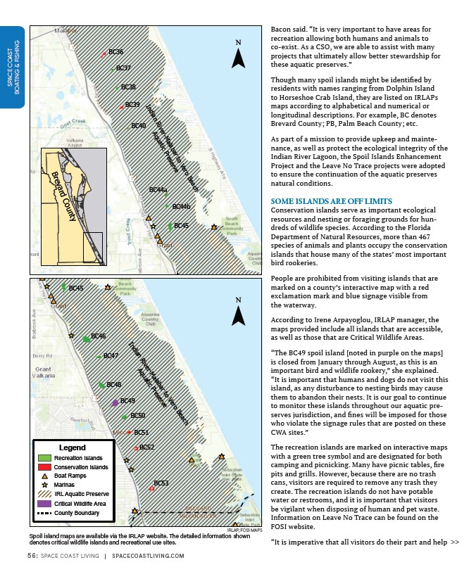
According to Irene Arpayoglou, IRLAP manager, the
maps provided include all islands that are accessible,
as well as those that are Critical Wildlife Areas.
“The BC49 spoil island noted in purple on the maps
is closed from January through August, as this is an
important bird and wildlife rookery,” she explained.
“It is important that humans and dogs do not visit this
island, as any disturbance to nesting birds may cause
them to abandon their nests. It is our goal to continue
to monitor these islands throughout our aquatic preserves
jurisdiction, and fines will be imposed for those
who violate the signage rules that are posted on these
CWA sites.”
The recreation islands are marked on interactive maps
with a green tree symbol and are designated for both
camping and picnicking. Many have picnic tables, fire
pits and grills. However, because there are no trash
cans, visitors are required to remove any trash they
create. The recreation islands do not have potable
water or restrooms, and it is important that visitors
be vigilant when disposing of human and pet waste.
Information on Leave No Trace can be found on the
FOSI website.
“It is imperative that all visitors do their part and help
IRLAP, FOSI MAPS
Spoil island maps are available via the IRLAP website. The detailed information shown
denotes critical wildlife islands and recreational use sites.
BOATING & FISHING
SPACE COAST
/SPACECOASTLIVING.COM